Indoor Mapping and Navigation Solutions

Indoor Mapping and Navigation Solutions Indoor spaces such as large facilities can be the most complex to navigate, they almost feel like a maze. Not only it often gets confusing, but navigation becomes a time-consuming and inefficient process. Spinclabs has a great solution for this problem. Our ‘Indoor Mapping and Navigation Solutions’ provide you with precise and user-friendly navigation. It optimizes picking and packing and the overall flow of logistics. Spinclabs creates smart digital maps and shows your exact location in real-time. Also, it helps you to transform these complex environments into interactive and intelligent spaces. Hence, it becomes easy for people to find their way, manage resources, and unlock new efficiencies. This helps businesses to work in a smarter way, improvise safety measures and make it easy for everyone to find their way around. With our advanced indoor mapping app and indoor navigation system, your operations are always one step ahead.

Indoor Mapping and Navigation Solutions

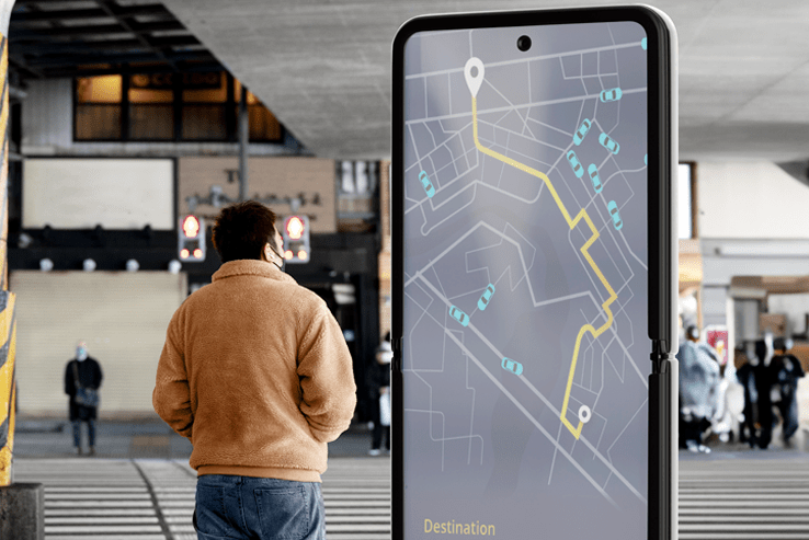
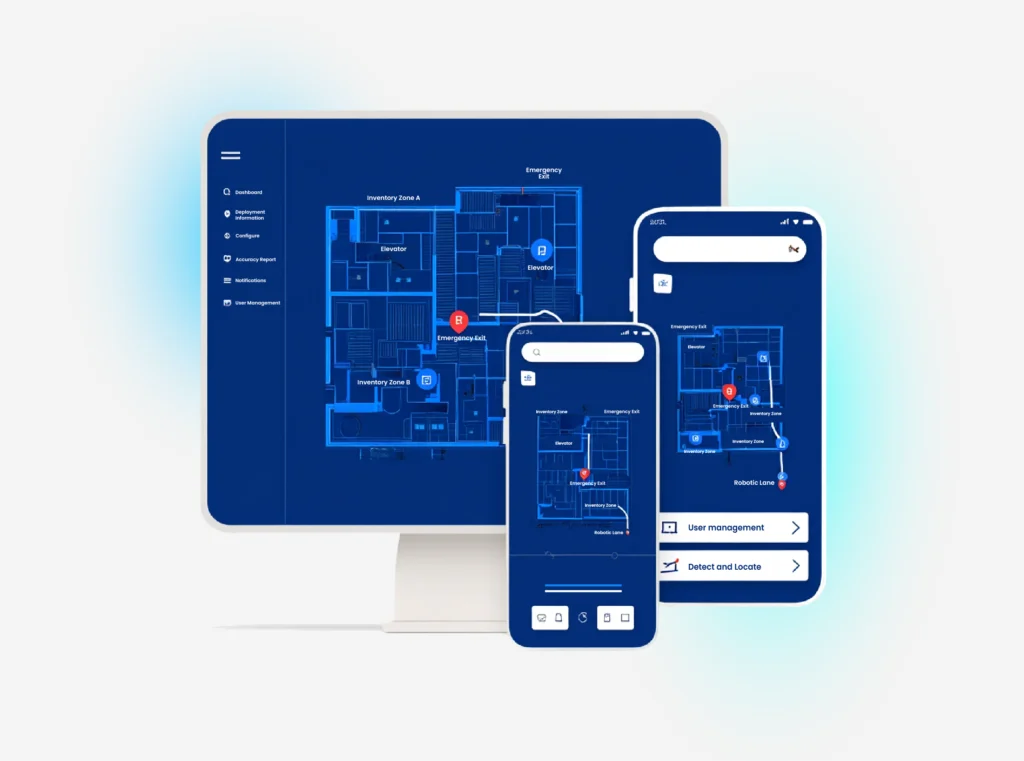
Indoor Map Digitization

This feature will be a great asset for you since we can convert your CAD or PDF floor plans. It uses advanced GIS tech, which can convert your floor plans into much easier and more accessible digital maps. Our process extracts key features such as points, lines, and polygons and geo-references them to real-world coordinates. Since we carefully trace all the shapes and lines and precisely link them to their real-world location, it makes the map extremely accurate. These highly accurate and navigable indoor maps are usually put into formats like GeoJSON and IMDF. So, this kind of final maps work smoothly with navigation apps and other smart systems. This advanced digitization of your complex floor plan lays the foundation for much easier and smoother navigation, indoor wayfinding, asset tracking, and smart facility management using top indoor mapping software.

How Does Our Indoor Positioning System Work?

Spinclabs’ Indoor Mapping and Navigation system fuses data from Wi-Fi, Bluetooth Low Energy (BLE) beacons, and smartphone sensors (compass, gyroscope, accelerometer) to pinpoint user locations with sub-5-meter accuracy. This works even when GPS fails, hence, it is beneficial for every business. As users move, their position updates in real-time accurately. It enables turn-by-turn navigation, asset tracking, and contextual notifications. The system also works with mobile apps, kiosks, and web platforms for a unified experience. Also, this hybrid approach outperforms Wi-Fi-only solutions (like Cisco Spaces) and avoids the high costs of Ultra-Wide Band (UWB) systems. The indoor positioning system integrates well with indoor planning and helps with precise indoor navigation app experiences.

Benefits of Indoor Mapping and Positioning

  • Your indoor data in one place: It centralizes all spatial data for easy access and management. Also, includes IoT feeds, and occupancy analytics into a single platform. With our indoor positioning system and indoor maps, you get everything streamlined.
  • Faster service delivery: Reduce your staff response times by 40% with optimized routing for maintenance or emergency teams. Hence, it guides staff and visitors efficiently, reducing delays and confusion. Our indoor mapping app improves service time and indoor planning.
  • Build a safer workplace: This enables emergency wayfinding, monitors crowd density, and supports contact tracing. This means it can trigger evacuation routes during crises or monitor restricted zones in real-time using your indoor navigation system.
  • Plan and manage your space: Analyze movement patterns, optimize layouts, and manage assets with precision. You can identify underutilized areas and redesign layouts using heat maps of foot traffic. Indoor mapping software plays a major role in planning and monitoring operations.

Use Cases of Indoor Mapping and Positioning

TrukrGPS caters to a wide range of industries:

Healthcare & Hospitals 

Hospitals

This guides patients to departments, tracks medical equipment such as ICU equipment etc, and manages facility services such as sanitization workflows. Indoor navigation and indoor wayfinding become seamless in medical facilities.

Airports & Transportation Hubs 

Airports

 Indoor mapping servies can help passengers or travelers to find gates, lounges, and amenities; also, coordinates staff in real-time and makes baggage handling easier using indoor navigation system.

Government Fleets

Retail Malls

Enhance shopper experience with wayfinding, promotions, and analytics. Also, boost sales with AR-powered navigation to stores and personalized offers based on visitor paths with our indoor map app.

Corporate Offices & Smart Buildings 

Offices

 Locate meeting rooms, manage hot-desking, and optimize space utilization using indoor navigation app.

Event & Venues

Events & Venues

Direct attendees, manage seating, and run targeted promotions using indoor maps.

Warehousing & Logistics 

Warehouses

Automate inventory tracking and optimize picker routes to cut fulfillment times using indoor planning and mapping software.

Create Smart Indoor Spaces with Indoor Positioning

We all are aware of how indoor mapping has become the need for smart buildings. It blends IoT devices and analytics, you can automate lighting, climate control, and security based on real-time occupancy and movement. With this, lights and HVAC adjust based on real-time occupancy, while security cameras focus on high-traffic zones. Hence, you can gain actionable insights to improve efficiency, safety, and user experience. It can turn ordinary buildings into intelligent ones and can create many responsive environments. Therefore, indoor maps have become more accessible. This mutualism and combination of mapping and IoT turns passive spaces into responsive environments that reduce energy costs by up to 30%. Use an indoor mapping solution or indoor map apps to optimize every corner of your facility.

Mobile App- PINNAR

Navigate Indoors with Our Mobile App- PINNAR

Our solution integrates with leading mobile apps like PINNAR, which uses AR and map-based navigation to guide users visually through complex spaces. PINNAR combines AR wayfinding with live updates. The key features include-


AR route overlays: Point your phone camera to see arrows directing you to restrooms or exits using our indoor
navigation app.

Multilingual support: Helps you serve global visitors with instant language switching.


Offline Mode: Access maps without internet in underground parking or remote facilities. Enjoy uninterrupted indoor navigation with our indoor map app.

Core Features of Our Indoor Navigation System

Indoor Map Conversion:

It digitizes floor plans into interactive, geo-referenced digital maps, which means manual CAD-to-digital validation for 99.9% accuracy using indoor mapping software.

Real-Time Location Tracking:

Continuously updates users (every 2 seconds via BLE/Wi-Fi fusion) and asset positions within the building through our indoor positioning system.

indoor mapping app
IoT & System Integration:

Turn-by-Turn Navigation:

Provides step-by-step directions to any point of interest and also, provides voice-guided routes with elevator/stairs preferences via the indoor navigation app.

IoT & System Integration:

Works smoothly on web, iOS, Android, and kiosks, all synchronized. Use our indoor mapping app anytime, anywhere.

Outdoor-to-Indoor Transition:

Smoothly guides users from outdoor GPS to indoor IPS navigation via a seamless indoor wayfinding experience. 

Cross-Platform Support:

Works smoothly on web, iOS, Android, and kiosks, all synchronized. Use our indoor mapping app anytime, anywhere.

Custom Analytics:

Delivers insights on movement, occupancy, and space utilization for indoor planning.

indoor mapping

Technologies We Use for Indoor Positioning

Bluetooth® Low Energy (BLE):

Deploys beacons for accurate, energy-efficient location tracking. These are highly efficient, low-cost and long-battery-life devices for high traffic areas in indoor positioning systems.

Wi-Fi-Based Positioning:

 Uses existing Wi-Fi infrastructure for device triangulation. This provides cost-effective scaling for your indoor navigation system. 

Ultra-Wide Band (UWB):

Provides high-precision tracking for critical applications. Hence, it can be deployed in critical zones for miniscule level precision.

Industries That Rely on Our Indoor Mapping Software

Retail & Shopping Mall

Retail & Shopping Mall

Healthcare & Hospitals 

Healthcare & Hospitals 

Airports & Transportation Hubs 

Airports & Transportation Hubs 

Corporate Offices & Smart Buildings 

Corporate Offices & Smart Buildings 

Warehousing & Logistics 

Warehousing & Logistics 

Event & Venues

Event Venues & Stadiums 

Government & Public Spaces

Government & Public Spaces

Why Choose Spinclabs for Indoor Wayfinding?

Scalable, accurate solutions
Scalable, accurate solutions: 

From small offices to mega-malls, our system adapts to any scale. Indoor mapping gives you highly accurate maps and reliable sub-5-meter positioning.

Industry-ready integrations: 

 It connects smoothly with your existing IT infrastructure, IoT devices, security systems, building management software, and popular navigation apps. This ensures a hassle-free implementation and powerful indoor navigation system.

Customizable and user-friendly: 

All maps, analytics, and navigation are customizable to your unique needs, all with an intuitive interface. We prioritize making navigation simple and effective for everyone.

Ready to Upgrade Your Indoor Experience?

Wondering how you can transform your complex spaces into intelligent, and navigable environments? Worry not, our indoor mapping system can help you. Connect to Spinclabs today and know how our indoor mapping and positioning solutions can enhance your operations, safety, and user satisfaction.

FAQs

Indoor navigation apps use a combination of BLE beacons, Wi-Fi signals, and smartphone sensors which determine the user’s position inside a building. Since the system updates the user’s location in real-time and provides turn-by-turn directions, navigation becomes an easy and efficient process. It gives access even in areas where GPS is unavailable.

You can use self-serve tools like Mappedin Maker or Pointr’s MapScale® to digitize floor plans and create interactive indoor maps. Many platforms offer free trials or basic versions to get started.

Indoor mapping is making every building smarter, safer, and easier to navigate. It is the process that converts physical spaces, like buildings or campuses, into digital maps. These digitalized maps help users visualize layouts, navigate spaces, and manage assets efficiently.

You can gain access to a digital floor map via mobile apps, kiosks, or web portals. It is super easy to use and provides users with directions, lets them search destinations, and receive real-time updates. Hence, it makes navigation and resource management seamless.

Top indoor mapping software includes features like easy digitization, real-time updates, analytics, and integration capabilities. Indoor Mapping and Navigation Solutions by Spinclabs have all these capabilities. This indoor navigation system is transforming how people experience and manage indoor spaces such as complex warehouses and other large facilities.